A Wilma Update
31 October 2005
"In the fields of observation, chance favors only the mind that is prepared"
Louis Pasteur
It was during last years Florida hurricane turkey shoot, when I was wrestling with how best to share what I had recently discovered regarding the naturalness of those hurricanes let alone all of this planet's now very bizarre weather patterns, that I decided that I must start weatherwars.info. I feel very strongly that people must know what is happening, but more importantly people have the right to know why they/we are dealing with weather as crazy as it currently is. Now here we are approaching the end of yet another first of its kind Atlantic hurricane season; this season has has so many firsts that even the most hardened skeptic must begin to wonder: "What if?"
I am not fond of jumping online and writing an article each time a big event comes along discussing whether or not the event is natural. If you have read much of my writing then you already know that my belief is that the use of scalar technologies, by many nations, have completely overwhelmed any of the remaining natural weather processes of this planets weather. To put it plainly: There is no natural weather left on planet Earth. None! Not these hurricanes, not the bitter cold that that I expect to settle in across the Eastern United States this winter, absolutely none of it any more.
Have you noticed the contrails overhead lately? The Powers that Be are using these contrails of a special fleet of planes to keep tabs on the ongoing weather manipulation. If you see the lasting contrails know that weather modification is happening in your skies!
Hurricanes now develop in locations that best suit the weather makers. No longer do they need to spend a week traversing the Tropical Atlantic gathering a name as they first become a depression while slowly strengthening to a tropical storm and then on to become a hurricane. Yes, explosive hurricane development has occurred in the past, but these past few years are different. There has been a discernable shift in how quickly and where these tropical storms develop and mature. Storms now form much closer to where the Powers That Be want the maximum terror effect. These storms are clearly government sponsored terrorist events. The effects are economic, are emotionally draining to the point of exhaustion, certainly financially taxing, and used to cause a victimhood mentality that makes us all feel powerless in some sense. The net effect is fatigue and in the case of Katrina and Rita we have been delivered an infection of poverty that this deeply indebted nation will struggle to overcome for a generation or more.
All weather is now manufactured. Period.
Where will Wilma and the the many following storms eventually head? Only those that are participating in and directing this eco-warfare know for certain.
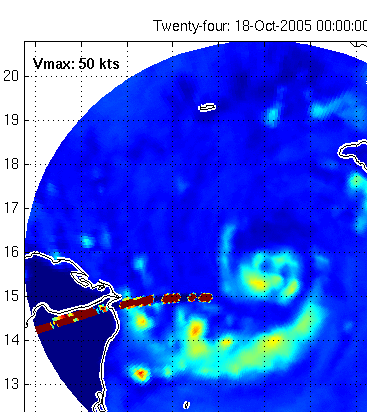
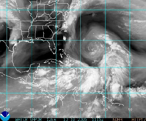
An in depth examination of the enlightening MIMIC imagery is underway. However, I don't believe that it will provide the skeptics with "Ah-ha!" moment that the believer want it to. TMIMIC data just is not refreshed frequently enough with gaps in the data loop that occasionally exceed eight (8) hours! Imagine trying to forecast thunderstorm development with those kinds of temporal holes. It cannot be done. Let us leave MIMIC where it belongs, as an interesting if not experimental view of the hurricanes in the microwave frequencies.
Complete weather data including the tropics is available from the University of Wisconsin.
http://cimss.ssec.wisc.edu/tropic/real-time/atlantic/storm/storm1.html
MIMIC Data for Wilma
http://cimss.ssec.wisc.edu/tropic/real-time/marti/2005_TWENTY-FOUR/webManager/mainpage.html
Far more weather manipulation is evident in the mimic imagery than just the 'fingers' that appear from time to time which seem to coincide with a change in vector of these storm's paths. That discussion and many examples will be saved for the future.
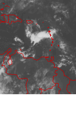
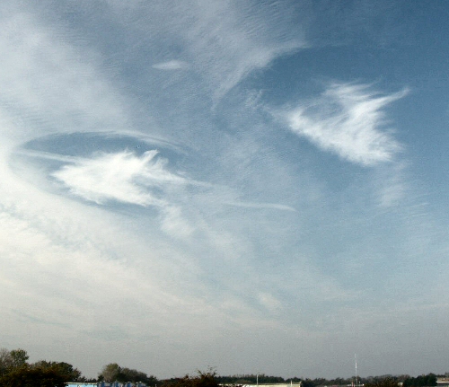
Wilma's "2"
This is what happens when man has a hand in the weather, unusual shapes eventually result. Also of interest to me is the disjointed outer feederband well to the WNW of the "2" where the outerband disintegrates into several thunderstorm groupings.
http://www.nbc-2.com/articles/readarticle.asp?articleid=4715&z=3&p=
LEE COUNTY - While watching NBC2 coverage of Hurricane Wilma about two dozen residents called the station reporting an unusual sighting. While watching a Doppler loop of Hurricane Wilma coming ashore, a number two appeared in the eye of the storm.
In going back through the recorded Doppler loop, we found exactly what viewers were talking about.
The image below was not altered in any way - it's a screen capture from the Doppler system. You can click 'play' above to watch the actual Doppler loop.
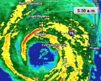
The Wilma '2' appears to be of the font:
Blue Highway "2"
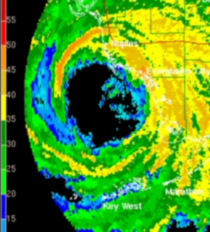
The above NWS Nextrad image was captured 24 Oct 2005 at 0956Z the same time as the NBC-2 radar but one frame, or six minutes, earlier than the archived link supplied with the NBC-2 article linked to above. Folks, this raw data cannot be faked. The question now becomes: Are we watching a deliberate signature purposefully embedded within 'Wilma' to convey some message? Or was the '2' a side effect of the EM-grid now responsible for creating our weather? Both lines of thought are reasonable. To achieve the manifestation of the straight line in the bottom of the '2' in the highly sheered environment of the eye of a hurricane is not an easy task. Maybe now that we all know of this manipulation, the Powers That Be (TPTB) will now begin inscribing the proper hurricane category within the eye of each storm. A destination location wouldn't be a bad bit of information to add either. Just a little sarcasm on my part.
The drawing of this number 2, within the eye of a catagory 2 hurricane and just as it makes landfall, is a clear demonstration of the technical capabilities and experience of the weather makers to inscribe or brand a hurricane in this fashion. What this means is that this hurricane, and the hurricanes to follow, will go where they are told to go.
Next year's hurricane season is going to be very interesting. As Florida and the Gulf Coast have already been hammered so very hard, I would look for the targets to be farther up the Atlantic seaboard during hurricane season 2006. Lets say from the landfall location of Hugo in Charleston, SC northward to New England. Thereby acheiving maximum terror and maximum damage in these very heavily populated cities. Can you imagine an evacuation of the D.C. region? That metro area can't even sustain everyday traffic without gross traffic congestion. Repeated hurricanes making landfall into the Mid Atlantic would be devastating by all accounts.
A Gaussian blur of .80 pixels has been applied to the NWS image to approximate the smoothing done to the NBC-2 radar image.
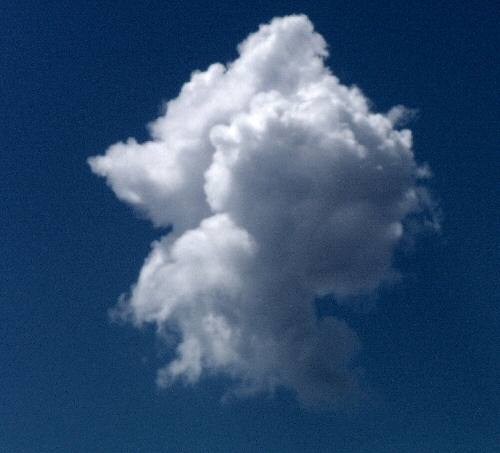
24 October 2005 1255Z/855AM EDT A variety of unusual energy signatures evident in the cloud tops as hurricane Wilma traverses south Florida.
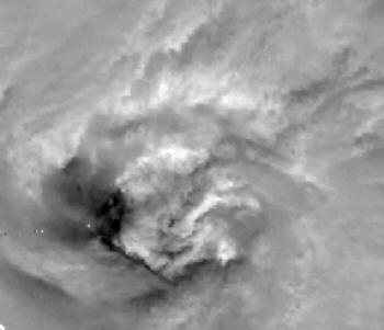
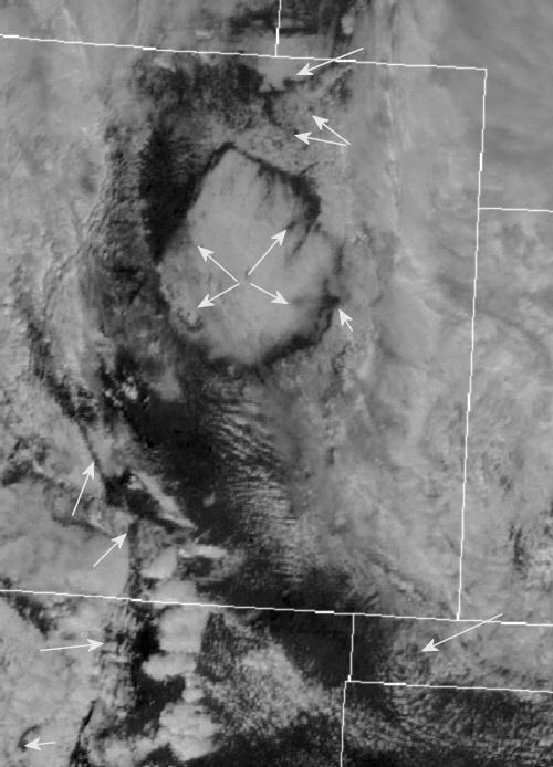
Wilma's eye has recently left the Florida Peninsula at 1640Z EDT 24 October 05
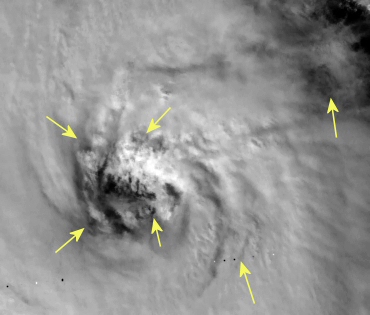
The Florida coast is just left in the image in the lowest left hand corner of the image. Hurricanes are rapidly rotating circular storms. With that being said one must then notice all of the straight lines embedded in the eyes of hurricanes during the recent past. This is not just a function of chaos in the eyes of these storms but the signature of manipulation. Holes at the ends of the straight lines are slam-dunk "Caught-You!" as seen in the previous picture.
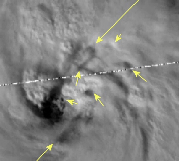
24 October 2005 1915Z 315pm EDT
More small diameter holes with straight lines embedded within the highly sheered environment of a hurricane.
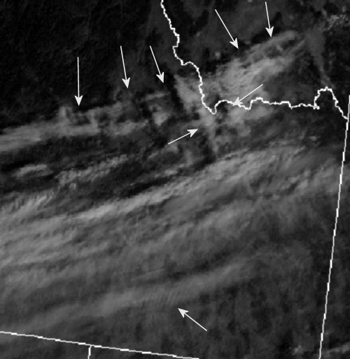
24 October 2005 2010Z 410PM EDT
Even as Wilma pulls farther and farther away from the Florida coastline the unnatural geometry continues to morph within the eye of this record setting storm. A bad scan line or transmission error runs through the exact eye of Wilma.
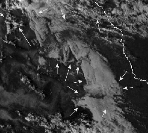
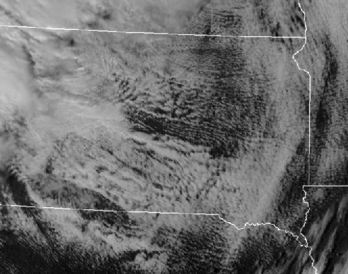
25 October 2005 2140Z 440PM CDT
South of the Rio Grande River/ Northeastern Mexico. The extent of the atmospheric manipulation is readily evident across northern Mexico late on this fall afternoon. The straight lines, irrespective of mountainous terrain, connected to companion holes punched out of the cloud cover.. Pie shapes and rippled wedges and more holes outlined by square clouds. This kind of geometry is a blatant signature of man!
31 October 2005
Watch this 12-hour satellite animation of the eastern Caribbean looking for pairs of darkening holes. These darkening holes are bursts of negative energy soaking up the energy contained within a storm. A fair analogy is that of a dry sponge soaking up moisture and heat removing that potential from a storm's development.
U.S. Military Wants to Own the Weather
http://www.space.com/scienceastronomy/051031_mystery_monday.html
What would a military strategist gain in having an "on-switch" to the weather?
Clearly, it offers the ability to degrade the effectiveness of enemy forces. That could come from flooding an opponent's encampment or airfield to generating downright downpours that disrupt enemy troop comfort levels. On the flipside, sparking a drought that cuts off fresh water can stir up morale problems for warfighting foes.
Even fooling around with fog and clouds can deny or create concealment - whichever weather manipulation does the needed job.
In this regard, nanotechnology could be utilized to create clouds of tiny smart particles. Atmospherically buoyant, these ultra-small computer particles could navigate themselves to block optical sensors. Alternatively, they might be used to provide an atmospheric electrical potential difference -- a way to precisely aim and time lightning strikes over the enemy's head - thereby concoct thunderbolts on demand.
Perhaps that's too far out for some. But some blue sky thinkers have already looked into these and other scenarios in "Weather as a Force Multiplier: Owning the Weather in 2025" - a research paper written by a seven person team of military officers and presented in 1996 as part of a larger study dubbed Air Force 2025.
Scott: Come on guys, we know that it is already done! Be a man and own up to it.
____________________________________________________________
'The Invisible Machine'
A look at electronic and microwave weapon technology through a forty-minute History Channel documentary. If there are skeptics out there this goes a long way in in removing doubt about the extent of the research and development of this means of waging terrorism and warfare. Is there any difference?
http://movies01.archive.org/opensource_movies/newsreal/indybay/uploads/invisible_machine.rm
This one-hour lecture by Lt. Col. Tom Bearden (retd.) includes a comprehensive overview and slide presentation of the fundamentals of scalar electromagnetic theory in addition to the named subject matter.
http://www.cheniere.org/video/index.html
Real Media player is required.
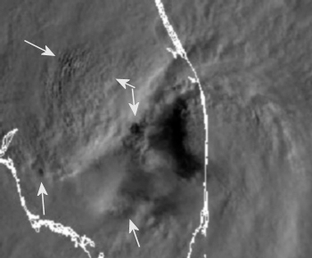
An atmospheric energy strike over Southern England--Little Hampton-- 16 October 2005. The military has sent out a contrail plane to check it out. This was not the only hole in the sky on this day. Note the rippling of the northeast side of the hole.
As standing gravity/scalar waves of varying intensity now circle the globe having created a reservoir of energy that is now available to draw into or out of weather events by the use of scalar interferometry. The Earth is an electrical battery with tremendous amounts of energy ALWAYS accessible. Scalar interferometry allows that to happen.
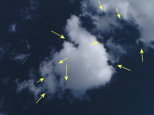
More clouds built on a square as a result of intercepting waves.
All thunderstorms are built as a combination of rotating squares offset just a little, usually at combinations of 30 and 60-degrees.
17 October 2005 2000Z Eastern Idaho
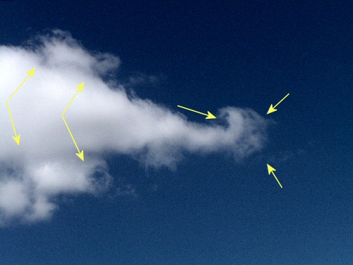
This is where I just don't understand why other weathermen just don't get it; whether or not they understand the energy budget aspect of how this is done or not. Every day, every hour, satellite imagery is replete with unusual geometry and unnatural shapes. How many examples of this does it take before a person can say, 'Hey something just doesn't look right!'
Eastern Colorado 11 October 2005 2000Z
Do you see the massive right-angled cloud reaching from Denver and to about 80 miles to the east?
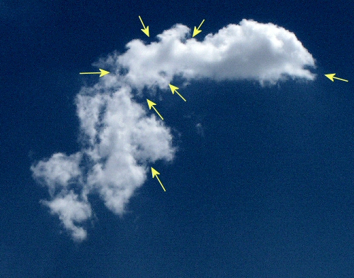
05 October 2005 2000Z South Dakota
Combinations of ripples and waves now comprise our weather.
Grid = A network of squares formed by horizontal and vertical
lines.
Scalar = A quantity, for example, mass or time, that has magnitude
but no direction.
Interferometry = A device that uses an interference pattern
to determine wave frequency, length, or velocity.
Field = PHYSICS an area or region within which a force exerts
an influence at every point.
October 10 2005 1115Z The actions of man's technology in the atmosphere often creates a geometry that, as seen above, often includes circles inscribed within a box. This configuration assists in keeping the enclosed storm-the circle-protected in a desired location longer than would naturally be the case. It was this particular set up that allowed the torrential rains to occur over the Northeast US at the beginning of October 2005.
______________________________
Does the United States Military have Space Based Assets to monitor the weather or even to exert influence on the weather from above? I have had more than a few emails asserting that we do.
The above image is a screen capture from CNN.com featuring video shot by a photographer from the CBS affiliate WFOR-TV out of Miami while Rita was churning through the Florida Straits. I don't know about you, but I see several red laser beams originating from two locations from the upper left and right.
http://www.ghcc.msfc.nasa.gov/sparcle/
"Direct tropospheric wind measurements would provide a greater impact on numerical weather prediction models than any other new space-based observation." National Polar-orbiting Operational Environmental Satellite System (NPOESS) Integrated Program Office (IPO), 28 June 1996.
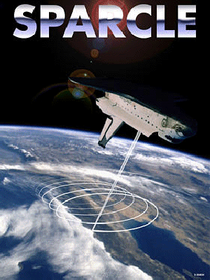
The NASA site says the SPAce Readiness Coherent Lidar Experiment was cancelled. That is too bad. It seems to me with the recent abysmal forecasting capabilities/track record that any additional data gathered that might lead to more accurate forecasts, hurricanes and all the rest of the weather that we deal with, could benefit from the deployment of some new technologies. Or maybe the military has developed/is using this for their own purposes. Some one has deployed this technology as the CNN/WFOR-TV image above confirms.
________________________
American meteorologist Scott Stevens has recently
brought accusations against Russia
http://english.pravda.ru/science/19/94/379/16227_hurricanes.html
Technologies of the secret research institutes that used too be classified and inaccessible become available to non-military researchers. One of the devices was recently tested thanks to support of the Russian Academy of Natural Sciences.
"We produced lots of interesting results during the first test of the ionic generator," said Academician Mikhail Shahramanyan. "A stream of oxygen ions was going up and could either result in a local rupture of the clouds or bring out overcast sky, depending on a work mode of the device. We managed to form cumulonimbus overcast sky over Erevan in April 2004. We used two GIONK type devices when the sky was clear. According to protocols verified by independent observers, between April 15 to April 16 in Erevan precipitation totaled to 25mm-27mm," said Academician Shahramanyan.
Weather Modification a Long-Established, Though Secretive, Reality
New legislation not designed to foster pleasant or productive weather, but planned as tool of weaponized weather control, already well tested and in use since 1976. Amateur and hostile weather-makers alike likely to lose their technology to the military.
http://pesn.com/2005/09/06/9600160_Weather_Modification/
Bill S.517 sets up an eleven-member board of directors to oversee all the research on weather control, and to direct funding to projects. The wording sounds typically bureaucratic and innocuous. Except for the fact that the title of the act includes the words "technology transfer," there is no specific reference to possible confiscation of privately-held equipment. However, there are gray areas, such as "and for other purposes" and other vague phrases that periodically appear in the text.
The above article takes the view that the government will confiscate the efforts of individuals and transfer their work into the government's domain. We, meaning all of the rest of us, need to insure that this bill builds a bridge from the dark shadows of the military and secret organizations and transfers this technology and ITS DAILY USE, into public oversight. It is my feeling that Congressional oversight will not be enough. Congress doesn't have the balls or the brains to be responsible for a subject of this importance to all of us. It is only through this action will we then be able to use this amazing technology with its capabilities for the mitigation of 'bad weather.' Because right now it is being used to create bad weather. This simply has to end.
The planet Earth has now become the weapon of choice; used to do the bidding of those with evil intent. In this manner they will never have to face responsibility or accountability for their actions. They are cowards of the first order! Cowards that are trying to create the conditions so that their New World Order can be born out of chaos that is of their own creation. The final goal of grinding these cities into the ground is poverty. Taking away all that these families have worked so hard for.. making them destitute while destroying the economic base of these many diverse geographic areas. Every government that allows the contrail/chemtrail over flights into their sovereign airspace is aware of this scalar warfare. Every one of these governments continues to lie to its citizens about why the weather is the way it is. But for now, global warming is the sorry excuse.
As of the middle of October more than half of the Gulf region's petroleum production remains shut in. Meaning that American oil companies have been unable to take advantage of the sharply higher oil prices that are available to them because they continue to be unable to get the product out of the ground or delivered to market. Who is making money out of the current situation? Everyone else. This includes OPEC which features the Bush lovin' Saudis who have pledged to pump all they can, and Russia with her incredibly vast natural resources. Follow the money...
http://www.financialsense.com/Market/puplava/2005/1020.html
__________________________________
Know this: Earth is NOT the only planet manifesting massive environmental changes. Yes, she has begun a fever, and just as our bodies also behave when sick, she will have chills and will tremble at times... But why? Can these huge planetary changes all be simply as a result of man made pollution? Not likely.
http://www.enterprisemission.com/_articles/05-14-2004_Interplanetary_Part_1/Interplanetary_1.htm
The entire solar system - not just our one small planet -- is currently undergoing profound, never-before-seen physical changes. This paper will address and scientifically document a wide variety of significant examples, drawing from a host of published mainstream sources.
We will also outline a new scientific model that, for the first time, coherently explains these simultaneous interplanetary changes via a fundamental "new Physics" - a Physics that predicts "even greater anomalies to come."
Here are some highlights:
Sun : More activity since 1940 than in previous 1150 years, combined
Mercury : Unexpected polar ice discovered, along with a surprisingly strong intrinsic magnetic field for a supposedly "dead" planet
Venus : 2500% increase in auroral brightness, and substantive global atmospheric changes in less than 30 years
Earth : Substantial and obvious world-wide weather and geophysical changes
Mars : "Global Warming," huge storms, disappearance of polar icecaps
Jupiter : Over 200% increase in brightness of surrounding plasma clouds
Saturn : Major decrease in equatorial jet stream velocities in only ~20 years, accompanied by surprising surge of X-rays from equator... plus a several minute change in the length of the day!
Uranus : "Really big, big changes" in brightness, increased global cloud activity
Neptune : 40% increase in atmospheric brightness
Pluto : 300% increase in atmospheric pressure, even as Pluto recedes farther from the Sun
None of these statistics are from "fringe" scientists; they are all very, very real, and what you have just read is only the proverbial "tip of the iceberg."
Head on over to enterprisemission.com to read the four part series on this most pressing issue that seems to have escaped the attention of our mainstream and/or our science press; both never quite seem to be capable of seeing, let alone comprehending the big picture. Too many disciplines are not sharing important information amongst each other... as not enough money, not enough pure research, too much political interference all combines with a woefully undereducated public leading to the current situation we find ourselves in today.
_____________________________________
One of these systems is the "electrochromic polymer" that is being developed at the University of Florida. These thin sheets cover the aircraft's skin and sense the hue, color, and brightness of the surrounding sky and ground. The image received is then projected onto the aircraft's opposite side. When charged to a certain voltage, these panels undergo color change. Another similar "skin" is being tested at the top-secret Groom Lake facility at Area 51 in Nevada. It is reputed to be composed of an "electro-magnetically conductive polyaniline-based radar-absorbent composite material." The system also utilizes photo-sensitive receptors all over the plane that scan the surrounding area, subsequently the data is interpreted by an onboard computer which outputs it much like a computer screen making the aircraft virtually invisible to sight.
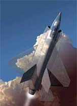
Ever wonder why some of these contrail/chemtrail planes just seem to disappear? This is just what information the Powers that Be have determined you can know now.
This image was taken at the same time as the first image at the top of this page at the location of Little Hampton England. Some external force has exerted an influence of the local atmosphere and a plane had to be vectored in to lay down a contrail to accomplish a survey of the local environment.
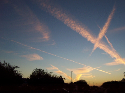
From Phoenix Arizona 30 September 2005-sunset As these Scalar EM-energy strikes occur in a drier desert atmosphere we can't see them quite as readily as in the image from England above. So the contrail planes have to use a gridded flight pattern to find them and mark out the physical intensity & dimensions of the EM energy being added to OR extracted from the local atmosphere. Each of the contrails in the above image tells a little bit of the story about what is happening in the skies over Phoenix this particular evening. Look more closely at your skies and watch the planes flying as chances are the ones that you do notice are not ferrying paying cargo from one location to another.
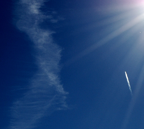
A chemtrail plane delivered this contorting/thinning out north-south trail about 20 minutes prior to me taking this image early in afternoon of 21 October 2005. None of the many north/south oriented flights over eastern Idaho are of commercial origin. There are maybe a few exceptions; but once one learns about the intent and observes the flight behavior of this fleet of aircraft it is a piece of cake [easy] to spot them. What we have above is another flight delivering a different marking contrail mixture along side the previous chemtrail. How the chemtrails behave, how they disperse, thin out, sheer apart are all ascertained from these flights across a wide variety of altitudes. All of this information is important to the warring parties. Remember that all sides have spacecraft that are capable of seeing what is happening over each others territory. There are few secrets in the skies that can be kept from each other's military. The general population, however, have been kept in the dark for much too long now.
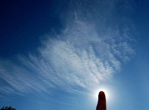
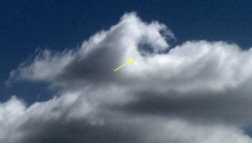
I also shot this image on 21 October 2005 which clearly demonstrates another feature/purpose of the chemtrails, and it is a beautifully simple one... To make these invisible scalar waves visible. Do you see the rippling/waves? Energy is being introduced into the atmosphere here and it is important to know this otherwise the plane would have been vectored to somewhere else with a higher priority.
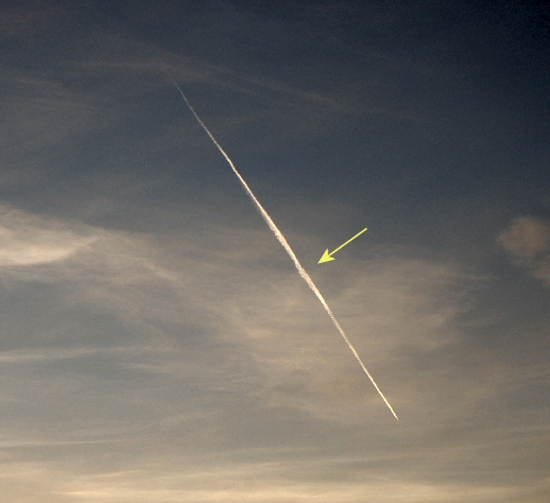
I took this picture, with my new Nikon D50 camera... let me tell you that this is one sweet camera... back on 20 October 2005 as the Sun was setting. The arrowed point is at the heart of a butterfly like shape (a scalar energy signature)that was one part of an energy dipole. This very specific location had to be marked. Why? You might ask...
The eventual destination of Category 5 Wilma, which was still in the western Caribbean, had yet to be determined. Meanwhile upstream, the contrail atmospheric marking planes were out in force and in numbers that I have never before witnessed. (Some may have been borrowed from Europe or other theaters of operation). These planes have been seen all the way from the Gulf of Mexico and Florida to the Alaskan Coast, as the jetstream was forecast to buckle delivering a very powerful, at least for October, cold front deep into the Gulf driving Wilma out across Florida and into the open waters of the Atlantic. This was to have been accomplished by early Saturday the 22nd. Then Wilma stalled.. While grinding human establishments across the affected area back into the ground bringing unspeakable torrents of rainfall. When would the cold front arrive to drag Wilma out of the warm waters and out into the cooler western Atlantic? These contrail planes were out marking the whole of the upstream jetstream for many thousands of miles to figure out whether or not this cold front would save Florida from the fate of Cancun and Cozumel.
And now we get to experience Tropical Storm 'Alpha'... Tropical season 2005 has been simply, amazing while rewriting the Atlantic Basin record book.
______________________________________
Holes Inside of Squares
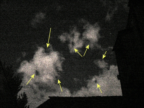
Watch these rotating holes as our clouds are now electrically whipped into existence rather than bubbling up from the warming convective up drafts as we are so frequently told.
Orgone Energy
http://www.aetherometry.com/mallove_appreciation.html
http://www.google.com/search?hl=en&q=Wilhelm+Reich&spell=1
The underlying geometry that provides Earth's atmosphere with it's very unique geometry may well likely be a function of the life force that underlies all of creation. This is still a very intriguing topic for me as I have a feeling that this area of study is going to be very important as we endeavor to gain a fuller understanding of many topics that touch any studies associated with the life sciences and our future interactions with this living planet of ours.